The Seattle winter was lasting a bit longer than expected this 2008. Let’s just say that snow in April, in Seattle, was not what I was expecting. It was cold and I needed to warm up. It so happened that I had some vacation time that had to be taken and a date with my dentist in San Francisco for some needed maintenance. I combined the two and planned a four day bike trip to Death Valley.
It had been almost exactly two years since the last time I was there on my Vstrom (no pics from that trip as I forgot my camera  ) There were a few new spots I wanted to explore and several others where I had gone to last time that needed some picture taking and additional exploration.
I flew down to San Francisco Thursday morning, had my dental appointment then proceeded to collect a few items to put my SV650 into shape for a 1000 mile plus weekend. With no major glitches I finished the bike tune up and pre packed (stashing of the tools, air compressor, tire plugs, dry bag, tent) for an early Friday morning start.
It was chilly early Friday. I was wearing my Gerbing electric liner but was not plugged in. Hey, its California right? No need for heat. Well, 75 miles south of SF and my first stop, Jerry’s in Hollister, had me near hypothermic. Your asking, so why didn’t you plug your electrics in? Well, its a strange thing once you get rolling on a bike. You just don’t want to stop for every little detail! I warmed up with some coffee and a classic eggs and bacon breakfast.
 Jerry’s has been the traditional biker meet up place for long haul trips to the south and south west of the Bay area. Its sort of a Jettson’s from the 50’s kind of motif. Two older gents were sitting at the end of the food bar, clearly they were regulars. One a bit grizzly, the other clean cut. Clean cut guy sez ‘ bit chilly, is it?’ I go through my ‘how silly I am for not plugging in my electrics’. The two of them joined by the manager of the restaurant sail off into tails about a cattle round up where the poor hands showed up with summer sleeping bags and froze their butts off. But I digress…
South of Hollister things open up. Not paying real attention to where I peel off of route 25 to head accross the central valley, I end up turning east on road called Panoche, a bit too far north of where I need to be when I hit the Central Valley. Great road. Passes Mercy hot springs and lots of barren just-barely-getting-to-spring land. An hour passes and I hit US 5 which marks the start of the Central Valley. I begin to remember the route and realize I’m actually to far north for the good roads on the east side of the Central Valley. Too late now unless I super slab it which I had no intention of doing. Better to go exploring.
Things start warming up but I leave on my layers of clothing. I know I’ll be climbing out of the Valley to get accross part of the southern Sierras and it’s still pretty early so the heat hasn’t hit quite yet.
The Central Valley is huge. It reminds me of the Great Plains. As you head east on 180, it gets hazy and the terrain is simply flat. No mountains can be seen in either direction. I fly through Fresno and finally start to get a few ripples in the earth. Mountains (Kings Canyon) can be seen in the distance. I set the GPS to find a route as far into the hills as I can but I end up zigging and zagging on Rt 63 south until I hit Rt 198. Here, my GPS tells me that I’ve been before and surprise, some really nice roads are ahead.
Departure into the hills is at Porterville. Old Stage Road is still close to the valley and it is Friday, so I’m battling double trailers full of Agra business. Still, the sweeping turns and hills make this a much more interesting ride. Old Stage Road departs from the agra business at Fountain Springs. A classic western bar painted a washed black sits at the intersection. Southeast lies more Stage Road and lots of empty miles of twisties!
I’m getting within range of my first night destination, Kernville. But not before two other spectacular central California Sierra mountain roads with no men with badges. Jack Ranch road and Rt 155 provide lots of entertainment. The quantity and distance these twisty roads go for rival the best I’ve been on. When you can say, you got vertigo from all the slamming back and forth, well ya know you’re having fun!
 At the top (6100 feet) of 155, you descend into Kernville with spectacular views of Lake Isabella (man made reservoir of the Kern river). My destination is the north side of Kernville heading into the Sierras. There are many great camp grounds along the Kern river road [mountain rd 99] (which ends in a dead end this time of year) and I planned on finding a patch of ground and setting up camp. Just a note on the camp ground. It is run by California, $17 no matter what. Single person, single bike, doesn’t matter. I found this a tad bit expensive for a site with only pit toilets but one doesn’t have much of a choice unless you wander off into the National Forest for dispersed camping.
Coincidently (well I knew it was happening) there was an adventure rider gathering of the central and southern California type in Kernville called Warped IV good. As I was continuing on to Death Valley the next day, I chose not to camp with this raudy crew but I did drop in for a beer on Friday night and chat with a few of the gang (notably ‘treadless’, the organizer). I checked out a lot of the hardware this crew was sporting, taking note of extra capacity gas containers and rear racks for DRZ400s machines. I was looking for truely adventurized DRZ400s but I only saw a few trailer queens. (Yes, I’m adventurizing a DRZ400s for a trip to Alaska!).
Friday night was chilly but I was in a nice warm sleeping bag and slept like the rock I was lying on!
 Saturday morning was in the low forties. Camp break down was fast and I hit the road by 6:30AM. My usual breakfast place in Kernville had not opened so I headed off towards DV via Sierra Way which skirts the north side of Lake Isabella. Electrics on and toasty. Sierra way ‘Tees’ into rt 178 which heads due east. A marvelous stretch of road that skirts the southern Sierras. The desert starts here. As I gained elevation, I came across a rather unusual tree (well thousands of them) that was in bloom. These blooms were on the end of each branch and were the size of my leg! Clearly a thriving forest of life at high elevation and low rain fall.
 When I finally reached Ridgecrest I was hungry and thirsty. A stop at a McDee’s for an egg and a muffin (about all that is edible there) and a quick latte at the local Star Bucks set me up for the final run into DV.
Panamint Valley was the next trip destination. A 50 mile length of low land. Flat and straight. I did the obligatory stop at the road to Ballarat (Ghost town) then headed out on a fine flat stretch of road. About three quarters the way through this valley the road intersects with at Tee. Left is Panamint valley road and is the quality paved road to DV. Straight has lots of warnings letting you know that the road is curvy and with lots of gravel. This road is called Wild Rose, and is the traditional biker road into the Valley of Death. It starts out nice enough. A straight road heading into the mountains.  The first thing you notice is how old the pavement is. The flat stretch is in good shape but the sun, sand and wind has worn off the top layers of tar leaving the stone exposed and polished. The elevation continues to increase, or at least that’s what the GPS is telling me. With everything so flat, it’s hard to tell that you are going up! Not until you hit the mountains, and cool air starts hitting you from the valley you’ve entered, do you realize that you have gained nearly 2,000 feet! That’s not all that changes as you enter the valley. The road gets twisty and the pavement is broken. Lots of stretches where there is only a two or three foot wide piece of good pavement. Fine for a motorcycle, not so good for a something on four wheels. Picking a line becomes important until no pavement exists at all! Gravel meets you and your lines are focused on the hardest pack you can see. Fortunately this is only a short section (less than a quarter mile) before you hit the intersection with Mahogany flat road. Wild Rose campground is situated here and there is a run up Mahogany flat road that takes you to the old charcoal kilns where wood was turned into charcoal for the smelters located in the valley.
  The road to the kilns is narrow, twisty and loaded with whoops. It does turn into gravel for two miles before it hits the rest area for the kilns. SV650 got dirty for its first time on the trip. Street tires and short suspension on dirt is a challenge but doable. I started to get my dirt legs going with thoughts of making the Aguerreberry point run.
After the visiting the Kiln I made tracks to Stove Pipe Wells with a couple of scenery stops along the way. Wild Rose road does some nice climbing (to 6,000 feet) with lots of great twisties. You descend from Emigrants pass (the highest point on Wild rose) and join up with highway 190. This road descends in pretty much a straight line, into the Valley. It was about 11:00 AM. As I descended on 190 I could feel the heat rising. Each 1000 feet raised the temp 10 degrees. By the time I hit Stove Pipe, it was a balmy 100F. I rolled into the side of the general store where all the bikers park. A couple of Harley’s and Honda cruisers were settled in and their riders were cooling in the shaded picnic table area. Getting off the bike I just started shedding clothes. When I got to my fleece T shirt and tights I ducked around the corner and finished with the warm clothes, swapping for some light cotton and nylon safari pants. When I got back around the corner, the Harley people were leaving. The two Honda people, one older guy and a middle aged gal named Sue were looking over some maps. Chatting it up a bit Sue, I learned they had been in the valley for a while and were heading north and east into Nevada. I warned them that it was a bit cooler up high. Sue is an avid rider with several bikes. Likes to take her sport bike out onto the twisties and her adventure bike into the dirt. Today they were both on cruisers for some long haul riding. It was heading onto noon and I bid my good byes.
Next stop was Furnace Creek where I found a nice camp site with lots of shade trees. Furnace Creek is one of a few fresh water spots in Death Valley. A true oasis. It acts as Death Valley’s National park center and has several restaurants, a general store and golf course with cabins you can rent and a nice pool with showers. For $5 you can buy a pass to the showers and pool which I did, to be used later on in the evening. For the moment, I was more interested in getting something cool to drink, some protien and gas for my sprints about the south end of the park. These sprints were on the order of 90 miles round trip!
I wanted to check the road leading out of the park on the east side. It is the continuation of 190 as it heads into Nevada. It climbs, but not quite as high as the west side. I was hoping to find some high altitude and some late blooming flowers, but this year was not quite as kind to the valley as 2005 when there seemed to be flowers everywhere from March through May. The winds were picking up a lot and I had to search for a safe spot to turn the bike around. Dropping back into the park the scenery was awesome.  Checking my rear view mirror I decided to take a chance and stop on the road to pull the camera out and take a picture. Just as I was putting it away, I spotted a car approaching from a distance. I could just catch a peek at it as it dipped into one of the small whoops. Black top with some white on the body. Hmmm. Bike in gear, I railed through first and second topping out at 55. Looking in the mirror and low and behold its a black and white CHP hauling up my ass. Sure glad I leveled out. I think he was upset that I did 0 to 55 in a couple of seconds. He blew by me on the double yellow. Whew!
In the three times that I had been to DV I never made it to Dante’s View. Now I had my chance to see what all the fuss was about. The road to Dante’s View is long and twisty with lots of 35 mile an hour speed signs. I made believe I didn’t see them. The views were nice.  I chose to take the path less traveled and was rewarded with solitude, a nice breeze and a spectacular view looking north, east and south of the Valley. Life is all around you in DV. You just need to pay attention. Lots of small flowers hiding in rock cracks, a rainbow of liken. Spiders, lizards, ravens. Quite entertaining when you spend some solitude time in the Valley. It was a real rejuvenating moment. One of many I had on this trip.
Making my way back down 190 I passed the exit to 20 Mule Team Valley and decided to take the entrance, about four miles down the hill, and try the loose gravel loop through what amounts to frozen sand dunes. Very loose but congealed sandy borax deposits slowly eroding. The ride was a matter of picking a good line on the hard pack. Nothing spectacularly difficult on a traily but the street tires did make it interesting.  Out of the borax and down the hill to Zebriskie point. This is another view spot over looking these strange, soft deposits. Now, not only borax but red, with iron, and black, with coal. This is the top of a place called Artists Palette that can be reached from the valley floor. Zebriskie point was my last stop before heading back to Furnace Creek for some dinner and recommendations for a sunset adventure.
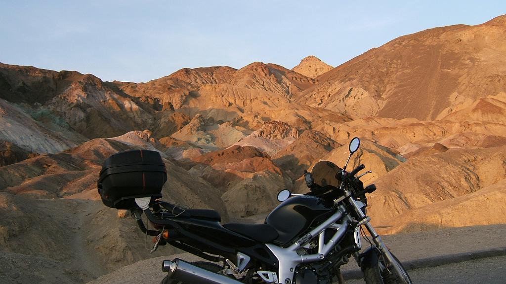
The Steak house at Furnace Creek is actually quite good for a National Park. Prices were reasonable and the wait staff was excellent. My waiter recommended Artists Palette for my sunset trek. So, I packed my camera, tiny tripod and headed out to Artists Palette for a spectacular sunset. I started taking pics on the main road as the sun was nearly set and the reds and golds were blazing. Racing into Artist Palette (another worn to the wind road)  I got there just in time to shoot my motorcycle-in-front-of-the-palette picture (see first picture above) and a couple of shots with me in them (rare to be sure). I had forgotten how gorgeous Artists Palette was. The road winds through these hills with so many different inorganic mineral colors. The setting sun pulling wonderful displays of reds, pinks, grays, whites and black from the ground.
The day was done. I headed back to camp, gathered my bathing suite and shower gear, headed to the pool where I enjoyed a wonderfully restful float and clean shower.
I’ve reached the half way point in my trip. My original plan had called for me to spend an entire day and two nights in DV. As I needed to catch a plane back to Seattle from San Francisco on Tuesday, and I didn’t see returning to San Francisco Tuesday morning and making the plane in time, I had to re-invent my trip.
I was up bright and early Sunday morning, packed up camp and was eating breakfast at a restaurant in Furnace Creek by 7:30AM. The plan for the day was to visit Titus Canyon then head back through Wild Rose with an optional trip to Aguerreberry point. Then, a spring back to Kernville for Sunday night.
Titus canyon has a stretch of dirt road that runs from the high plateau on the Nevada border, down, into the Valley. I had been forewarned that the top is very sandy so I opted not to ride the bike. There is a hike from the valley into the canyon which takes in much of the lower section. But even that is a two mile stretch of dirt just to get to the mountains jutting out of the valley floor.
Its mid morning and I can already feel the heat. There are a few cars parked in the Titus canyon rest area and the road neatly ducks into the canyon between two vaulting walls. Where there is shade the canyon is cool.  There are large stretches of canyon angled to get the sun. The floor gradually climbs. This part of the road in the canyon is actually quite solid and would not have been a problem on the SV, but then, I probably would not have had a chance to actually ‘look’ at the canyon! After a four mile hike round trip, it was time to head out of Valley.
Gassing, cooling off and enjoying a cold drink at Stove Pipe Wells, I ran across a new Vstrom rider. 1500 miles on his bike so far. An older fellow, (I should talk) and his first adventure ride. Not a spec of dirt on this bike but I had to ask if he had ventured onto the gravel. He gave me a surprised look and said he didn’t think he had the right bike for that. I just chuckled a little and said that he was in better shape than I was. I told him I was thinking about Aguerreberry point but that was 18 miles of gravel round trip. He was content to venture on to Wild Rose as his more aggressive route. I recall the first time I was in DV and had exactly the same thoughts (although, I _was_ on my Ducati Monster!).
Still quite apprehensive about taking the SV on more dirt, I boogied up Wild Rose, past SKIDO (where a couple of real dirt bikes were having fun) and came to the Aguerreberry point turn off. Without hesitation, I turned onto the gravel and made dust along the valley. Aguerreberry was calling to me so I had to make the journey. Putting along at 25 to 35 mph I found the going pretty easy as long as I stuck close to the side of the road where the gravel was hard and there was no washboard. Something glinted in my mirror, but I didn’t catch it. A few minutes later, the two dirt bikes were coming up my tail. I hugged the side of the road and waved them by. I would probably run across them at the end of the road.
There are only a couple of challenging spots on this road (besides the loose gravel and washboard). It passes through a small canyon which requires some technical turns then rises across some exposed rock. As long as you have some momentum, the lines up this section are pretty easy.  The final run to the edge of the mountain is gradual and easy, although you really don’t notice that you are really climbing. The view is quite a surprise after you roll over the last rise. The road leads up to the actual point but is steep, curvy and with cliffs alternating on either side. Much easier on the Vstrom or a dirt bike then the SV.
The Dirt bike riders are at the top taking pictures. A guy and a gal. The gal comes down to chat, all smiles. They were from Berkeley and were heading towards the Grand Canyon for a rafting trip. We exchanged adventure stories and enjoyed the warm sun, cool air and grand view. You meet the greatest people out in the middle of nowhere!
I clambered over the rocks and made my way out to the farthest point on Aguerreberry. Taking in the quiet wind and amazing view, I pulled out a little container. My dear friend Craig had taken me up here once. He had passed away and I had a few of his ashes with me.  Opening the container, I wished him peace and spread a bit of him on the wind. The powdery ash swirled and expanded as the updraft took hold and absorbed the remains into the perpetual air cycle of the Valley.
I bid my new friends goodbye and headed back out Aguerreberry road stopping to take a look at the abandoned Eureka mine. There, I collected my obligatory trip rock (I always try to find an unnusal but representative rock on my trips) and took off down Wild Rose for my sprint to Kernville.
I got into Kernville pretty late so set up camp cleaned up a bit and went down to a steak/brewery house. A nice waitress with a Kiwi accent drew four samples of their beer for me. I chose a nice strawberry ale which I drank down and relaxed in the evening air. The steak was good too!
The final 400 mile ride back to SF on Monday was that sort of let down feeling. The first segment was the nice 50 mile stretch of twisties which really raised my spirit. It was cool but not cold. I was getting into a great rhythm and fine tuning my turns, getting the apex just right for those blind corners with reducing radiuses. It was on one of those corners that I found out how lucky I was. About 30 miles into this great road, I was boogieing. Dialing in the corners. I was cookin on one turn, had a great line and just at the apex as I was crossing the center of my lane my front tire caught some sand and washed out about eight inches before it stuck. Stood the bike up (not a good thing) and nearly threw me off. I recovered and was entering the wrong lane ready to pitch it hard when of all things, a lady is walking two dogs up the road in half that lane. I had three choices: 1) low side and take us all out, 2) pitch it hard and hope it sticks and the lady jumps put of the way 3) grab brakes and aim for the broken pavement between her and the cliff. I chose door number three and lived to turn the bike around and appologize for giving the lady a heart attack!!!! Mind you, I have no idea where she was walking from. There were no camp sites, no homes, nothing. Lesson learned: blind corners with soft sandstone embankments are a low side waiting to happen.
The Central Valley crossing was dull as usual. I took 198 and picked up rt 25 at its most southern point. 25 was sweet, with lots of meadows covered in wild flowers. Some places were solid yellow. Others had little ripples of yellow and red.
I returned safely and crashed that evening at my San Francisco pad sleeping a solid 12 hours!
Paula, Adventure Girl
Recent Comments