Gazing on a brilliant field of yellow that brings the mind to a vibrant calm. Brilliant blues that mock the sky. Greens and oranges that pop out from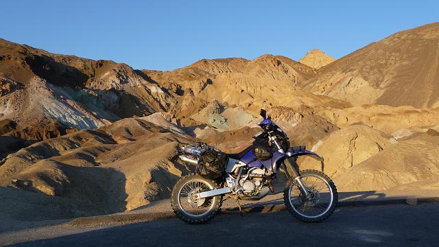 the air. These are the sights that can be found in the flowers from the sea to the desert of southern California and what my mind’s eye was in search of for my fourth trip to Death Valley. My past three trips were fast and furious rides down to , through and back from Death Valley with little more than one day to spend in the park. This time there would be time. Time to find the near and far life force of the Valley. Time to discover the greening and wild colors that winter rains bring to this below sea level desolate place. Time to uncover the topology and geology of warm springs, dry lake beds and the many minerals and metals of this wilderness. My plan formed during my previous trip to Death Valley. I was riding a street bike during that trip and knew that I was missing all the sites, sounds and adventure of the desert back country. I had to return. This time with my trusty adventure proven dual sport bike, my DRZ400.
This is a ride report for my 2009 solo dual sport trip to, through and from Death Valley. If you just want to see the pictures go here. The report was a year in the making. Hope you enjoy it! Paula Keezer.
Is there anybody out there? Just nod if you can hear me! My attempts to find like-minded riders for an early spring trip to the Valley proved luckless. Un daunted, I planned my trip solo starting with trucking my DRZ down to San Francisco from Seattle on Christmas Eve. That was an adventure un to itself! Seattle and the NW got hit with the worst snow in decades. Rt 5 south was a disaster from Seattle to Salem Oregon. That portion of the trip took me twelve hours alone, what it usually takes me to do the entire trip. I made it though, and stored my bike at my San Francisco home for use in the spring.
This would be a back country trip to places where I might not see anyone for days. Not the most hospitable place to be and clearly dangerous to do solo when a little slip on a motorcycle could send you off a cliff. I invested in a SPOT personal location device. Rather neat gizmo that the Alaska trip proved was a viable means of tracking in very remote areas.. It has a gps built in and sends your location to a satellite and back down to a web site where a friend can keep track of your progress and respond to any requests for help. A great investment for peace of mind. I would not have covered the ground that I did if I didn’t have the magic button on the SPOT.
I made my preps, got my maps and GPS loaded, logged my vacation and headed out for a ten day adventure. A day and a half down and a day and a half back with seven days in Death Valley and no particular hard and fast plans, just a general west entrance, south park, east entrance and north park strategy. What roads I would travel I did not know but they would be dirt and remote a many.
I flew into San Francisco a couple of days early loaded with 50 lbs of gear in my big duffle. Spent a day getting last minute REI goodies and final prepping the bike (most of the work was done in the previous fall). Saturday morning it was time to ‘put it in gear’ and head south on the first leg of this ten day trip.
It was cool (as in weather cool) heading south but I had my electric jacket liner to keep things comfy. The new knobbies (tires) and the DRZ buzz from the single cylinder thumper was tedious for the first 100 miles of highway. Once off 101 south, and the speed dropped to a comfortable level, the DRZ settled into a tolerable ride.
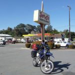 First stop was Jerry’s in Hollister. A favorite breakfast dive for the adventure rider crowds heading south from the Bay area to central, southern, and south eastern California. If I were meeting a group, this would have been the gathering point. Alas, I am alone on this trip and no other riders are around. I have a cup of coffee and some scrambled eggs to tide me over till dinner. Still a good 250 miles to go.
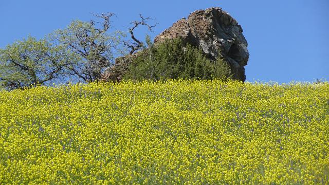
Heading south out of Hollister I get into real country. Lots of pastures and small wood. Here, the flowers begin. Yellow is the color of choice with the green grass coming in a close second. It’s still a bit early for the trees to green out but the buds are present. It’s sunny, and the day begins to warm up. There are a few horses and some cattle in the fields who give me a slow gaze as I motor by with the deep grunt of the DRZ’s exhaust. 25 is a fun road. Lots of twisties. Really made for a sport bike but I put the thumper (what a single cylinder bike is called) through its paces and get my new knobbies worn in.
It doesn’t’ take long to acclimate with the solitude of the country side. Rt 25 and Parkfield road are nearly deserted. Its so much less stressful to ride a motor bike in these parts compared to the highway or city. Parkfield road connects 25 at rt 198 to the town of Parkfield which is the earthquake capital of the United States. The ground is always shaking there however not as I pass through. Parkfield road starts out as a single lane paved road that rises into the hills then turns to dirt and descends into Parkfield. Here is where my eyes get their first savoring of a field of wildflowers. 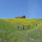 Yellow of course. Brilliant sun defying yellow gilded across a hillside. This gives way to green grasses and the road switches back and forth as it descends into Parkfield. I ride by the Parkfield brewery where the pavement begins again and is the end of the road for a few dozen Harley riders gathering for a pre noon brew. I reach Cholame road and turn east towards the dust of the central valley leaving behind the lush greens and yellows of the coastal hills.
The central valley is crisscrossed with all sorts of roads. Highways, secondary roads and even a bit of dirt. It is long and flat. Very un-interesting. My choice was to find a secondary road and just get across. Heading south east, I hit a place called four corners where there is gas and a large warehouse set up as a local nut and fruit stand by the native American population. I gas up and grab some very nice nuts and dried fruit for snacks and emergency rations for, my trip. The temperatures have warmed and its nice to sit on the curb in the sun.
Heading east now, I enter the lower Sierras at Kern river canyon. Here are some serious canyon twisties that go on till you hit lake Elisabeth and Kernville. My DRZ is not the best bike for canyon carving but any bike on a curvy road is real fun. Being a bit slower then a sports bike but just as technical, it’s pretty easy to keep space between you and a car or truck in front of you so I pretty much have the road to myself.
Looking at the GPS I see some of the hotsprings that are present along the Kern and decide to investigate. I get to pick up a bit of dirt riding down to the Kern along the canyon but these hotsprings are private and gated. No soaking here.
Finally I get into Kervnville, my destination for the day. I roll into town, gass up, and look for the BB I’ve reserved a room at.. a quite place just off the main road by the river in downtown Kernville.
Recently renovated, the Kern River Inn is run by an eclectic fastidious older woman. I’m a bit of a site to see in my full motorcycle gear, looking more llke a space person then a human. She looks me up and down and asked who I am. “I’m Paula!”. “You’re Paula? I wasn’t expecting a woman on a motorcycle! Come on in, let me show you to your room” and so it goes with the BB style here is your room, your bathroom, pastries and coffee here, breakfast served at…. there’s a parking space out back you can grab for your bike….
I unload part of the bike out front as it is closer to my downstairs bedroom. I leave most of my gear in my saddle bags but bring in my big dry bag that has my clothes and toiletries. I feel the eyes of the owner on me as I select what comes in and what stays. Move the bike out back, take a shower, grab some tea and pastry, sit on the front porch.
There are four other patron groups (I’m the only solo) and they meander in and out over time giving me an odd look as I am alone.
The Kernville Inn is by the river and on a river road where river side is a park and homes or more precisely Inns line up the other side. Behind the Inns (and motels) is a service road that provides access to the back of the Inns and the back of the restaurants that line the main road through Kernville. Why is this important. Well its not. I just thought I would give a picture of where I rode my bike to find the back parking area for the Inn!
Mary, my Inn keeper chatted incessantly either on the phone or to her cats and dogs. To the dog she would say “that was a good treat and you better behave or you won’t see another” To the cats she would say “Just because you are at the door doesn’t mean it will open” This projection of personality on the animals went on all night, or at least while Mary was not on the phone.
Having had dinner, I retired to the front porch with a cup of tea and enjoyed the river view and quiet street. The day drew to an end and darkness settled deeply around the Inn.. I retired to my room showered and curled up in the down bed falling fast asleep.
A rooster crowed and a dog barked waking me up from a sound sleep. No other sounds found their way into my room and I rolled over to catch a few more zzzzs. The clacking of dishes by Mary forced me to reconsider sleep and I rolled onto the floor snatching bits of clothing: fleece tights, cargo pants, fleece top, socks, motorcycle boots.
Grabbing a few packed articles, I tromped through the dining area and out into the parking lot to begin packing the DRZ. The smell of coffee soon drew me back inside to the sizzling sound of bacon. The breakfast in Bed and Breakfast was well on its way. Back in my room, I finished packing and moved the rest of my gear out to my motorcycle, Tied things down, kicked the tires, oiled the chain, while one of the patrons looked on.
“What kind of bike is that? Where are you headed to? Those tires look like off road tires” He was a middle aged gent who knew a little but not a lot about motorbikes. His group consisted of his wife, son and daughter inlaw. He was a bit chatty. He told me of some jeep adventures they had in Death Valley. Their afternoon adventure would be more local though. A Kernville mountain peak with some dazzling displays of, you guessed it, wildflowers!
Less adventurous patrons slowly arrive to the breakfast table. A couple from LA visiting Kernville for some quiet time, Another couple passing through on their way to Mammoth Hot Springs. The bacon, eggs waffles, pastries were passed around the table and we all ate ravenously.
With a full stomach, I took my leave, thanking Mary and wishing all well, pulled my riding gear on, mounted my DRZ, plugged in my electrics and headed east towards Ridgecrest
 I felt the chill of the morning on my face as I carved the canyon walls on the side of Lake Elizabeth. My electric jacket continued to put heat out so I was comfortable inside my layers of riding gear. The road was empty and I simply kept a good pace through the twisties. Turning on to rd 98 the road began to rise in elevation through farm land, then cattle land and finally high desert as I went over the first of a series of low passes that take you deeper in
to the Great Basin and its deepest valley.
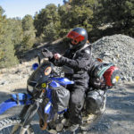
I stopped at the Walgreen’s in Ridgecrest as I had a blocked tear duct and want to get some eye drops to help lubricate my eye. To my delight, there were to adventure rider bikes in the parking lot so I pulled into one of the spots near the bikes. As I dismounted, two fellow riders were leaving the Walgreen’s and greeted me with accolades about my bike. They were Marty and Max and heading to Death Valley as well. Riding big beamers, they would be staying on the well traveled and maintained paved and dirt roads in the park. Marty and Max would be making an attempt at Mahogany Flats as their evening destination. I had other plans but if the plans didn’t work out I would try to find them and share some stories. Its always great to meet up with other motorcycle adventure riders. We are a strange breed, riding our bikes geared for self sufficiency.
After a cup of Starbucks coffee and a few provisions from the local grocery store (the last I would see until I complete my Death Valley adventure) I once again 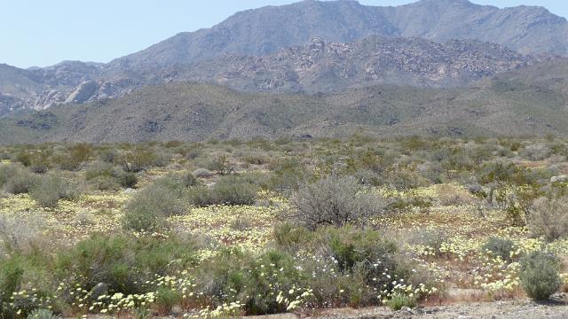 headed east and out into the desert. Here is where I found my first desert wild flowers in earnest. Hill sides covered in yellow and white. Outer Ridgecrest must have gotten some rain because these flowers went on for twenty miles or more. Reaching the second pass over some low mountains, I reach the pinnacles valley. This valley feels the ravages of strip mining where white soft minerals in the form of salts and borax are mined. The operation here is huge. It involves the entire valley. Salt dust is picked up by the wind creating giant dust storms that are pushed south and east away from the road I am on. Here is where I top of the gas on the DRZ. Last gas before I am in the park. Two groups of dual sport riders with a minimum of support gear come through to gas up. They range in age from teenagers to retirees. No age discrimination here. I was disappointed that there were no women riders. In fact the only women riders I had seen pass through this gas station were riding on the back of Harley’s.
Gassed up and hydrated I head into the desert.
I Pass into Panamint valley and the land opens up to the horizon. Panamint is 65 miles long. The main road turns into a point in the distance but thats not where I am headed. I take the cuttoff to Ballarat. A town that supported the marginal mining in the Panamint range, the range that separates Panamint valley from Death Valley. Now a ghost town, Ballarat is home to a single general store run by Rocky. The cooler and electric fans are run by a small set of solar panels.. Rocky offers me something cold so I pick out a coke and leave a ‘donation’ of 5 bucks. (expensive coke but he doesn’t get much business out there!)..  The front porch of the general store has a group of old timers with cowboy hats on jabbering it up about their conquests in Las Vegas and Beaty Nevada. I get a chance to chat about Pleasant canyon road with a young man who is camping at the Ballarat camp site. My primary plan from Ballarat is to take Pleasant Canyon road into the mountains and camp at the ‘parks’, flat areas, butte like, near the top of the range.
I bid goodbye to the local chapter of boys in Ballarat and head up Pleasant Canyon road, I think.. The road gets steep and rough pretty quick. My DRZ is a mountain goat and eats up the road until I hit an area that has been torn up by some heavy equipment. The road turns into deep silt and I find myself stopping and starting in short bursts to dig out and up on top of the rutted silt. At one point my rear wheel digs in past the rim while my front wheel gets braced against a pile of silt/dirt. I’m in deep enough I can step off the bike while the bike is up right and drag the front wheel away from the dirt pile, climb back on and engage the knobbies to get me going again. By this time my heart is pounding. I’m trying to decide if I’m even on the right road. Should I have turned at that spur half mile back? Is this the dead end spur thats on the map? The road improves (slightly) and I continue on, passing the heavy equipment that has torn the road up.
The road takes a sharp left, rises and is torn up well beyond my capabilities. At this point I decide its time to turn around and take a look at the fork further back. Going down through the rutted silt is much easier but still an adrenalin rush as I’m going very slow with lots of foot dabbing.
The turn I’m looking for seems to have disappeared. I realize this as Ballarat comes into site and I resign myself to flying down the four track dirt road on the east side of Panamint valley called Indian Ranch Road. The DRZ eats this sandy gravel road at 60+ and is a nice consolation to Pleasant Canyon. After 25 miles of high speed dirt adrenalin, I reach Wild Rose road.
Wild Rose is a poorly maintained paved road that rapidly climbs into the Panamint range towards a 6000 foot pass called Emigrants pass. Passing into the canyons, the road gets excessively potholed. Bad for four wheels, easy for two wheels as it give me a challenge to wind through the road ‘features’ at a nice clip. This section of Wild Rose has several springs where water runs out over the road. Water coupled with the higher elevation means ice in winter leaving pot holes. The National park identifies the road as a high clearance vehicle road. They keep the road open but do not maintain the pavement. Wild Rose road takes a sharp left at a T intersection. I’m at 6000 feet but with the sun, its still pretty warm. Heading right (east) takes me deeper into the mountains towards the ‘Kilns’, Thorndike campground and Mahogany Flats. The day is getting late and I make the decision to head into the mountains looking for Marty and Max at Mahogany Flats. The road to the Kilns is nasty and nice. Lots of wash board from two wheel drive vehicles not made for going up hill on dirt roads. And lots of whoops. A whoop is where the road dips down and rises back up or rises quickly and dips back down. Its a place where I can catch some air if I go fast enough!.
The charcoal kilns are large beehive like structures that were constructed by early Death Valley entrepreneurs to supply the valley with charcoal. Why does a 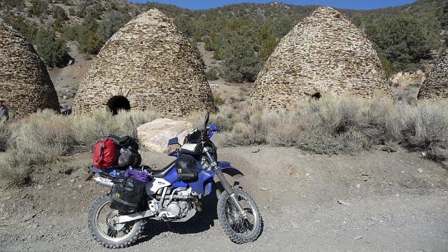 place that reaches 120F in the shade need charcoal? Places like Stove Pipe Wells were used to smelt down the ore that Death Valley miners brought. To smelt, the proprietors needed charcoal. Charcoal had to be made from wood and wood is not plentiful in Death Valley but is plentiful in the high mountains. The charcoal kilns were constructed at the tree line.. Trees were cut down higher up in places like Mahogany flats and burned in the kilns, reduced to high grade charcoal that was transported to the smelters in the valley.
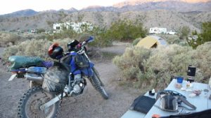
Today, there is a crowd of sedans and tourists marveling at the beehives and taking their leave at the parks rest room. I’m headed further into the mountains. The road gets quite a bit rougher here as I leave the tourist route behind. Rising another 300 to 400 feet I begin to encounter the unexpected. The road is damp, muddy and getting whiter. Snow is still holding its grip here at 8000 feet. I pass through Thorndike campground and reach a closed gate. The road is fully snow covered and Mahogany flats is still miles further in. Thorndike is my stop and I take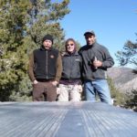 a look around. Sure enough, Marty and Max have set up camp at the highest site in Thorndike. They have an inviting campfire going. Marty sez, ‘find a spot’. I park the bike and set up camp on the last remaining flat dry ground.
Did I mention that it was the first week of April? At 8000 feet it can get pretty dang cold. As the sun was setting Marty, Max and I scrambled around the hill side collecting dead wood and building a pretty good reserve pile. We had a nice fire going. I lit up my turbo boiler (boils water in under a minute) and heated enough water for some dried soup and a cup of tea. My handy dandy stadium camp chair was just perfect for sitting on the cold aluminum picnic table bench. I watched as Marty and Max got their white fuel burners going and chided them on the time it took to cook up their meals! we have some great conversations about past trips, craziest situations, and finest moments. One in particular sticks in my mind:
Marty: “Paula, have you ever done the lost coast and Usla road?'”
“Nope, but its on my list”
“You’ve got to promise me that the next time you go up the coast, to take Usla road. It connects the end of Rt 1 with the lost coast!. Unmaintained dirt road but your DRZ is perfect for it. Max and I did it a few years back on our big bore bikes so you would have no problem.”
“So Marty, whats it like? two track? grass track, rutted, muddy?”
“All of he above. Max, do you remember that ride? There was definitely mud”
Max: “Yeah there was mud! Remember the local yocals with their welded together four by four buried to the axles hauling them selves out with a winch?”
“Oh yeah, we asked how deep the mud was. They said the last motorcycle riders went in and disappeared!. We made it through okay though. Just have to pick the right line”
Paula: “Okay Marty, where was the mud holes? The beginning? the end? the middle?”
“Oh, lets see, Max, it was at the begging right? Yeah, the beginning.”
“Okay Marty, which beginning. Heading north or heading south?”
“Geeze Paula, I don’t remember. I just remember there wasn’t to much dirt before we hit the mud!”
“Bloody hell Marty, Thanks alot! So I won’t know if I’m at the beginning or end and when to expect the mother of all mud holes!”
After a few more adventure stories we all packed it in for the night.
It was cold, really cold. I had my thermarest pad between me and the ground, I was buried inside a 0 degree sleeping bag with an added silk liner (good for another -10 degrees and I had all my fleece on with my socks. I never got hypothermia but I was never comfortable. It seemed I always had some cold spot I was trying to rotate out.
Morning finally came. I check my water bottles that I had placed inside my tent and they had not froze. That was a good sign. It never got below freezing inside the tent. I could hear Marty and Max stirring so I carefully . climbed out of the sleeping bag into the cold air, I pulled on my cargo pants over my fleece and put my jacket liner on, boots and climbed out of my tent. It was really cold and the sun would not be hitting us for at least an hour.
So how cold was it? Marty placed his camp pan on the aluminum picnic table and poured water into it. The water immediately froze. Hmm, probably below 20F. Max’s thermometer was reading 15 degrees. I haven’t camped in that kind of cold since I was on a camp out when I was in my teens. Fireing up my boiler again, I get my hot water and mix up my bag of oatmeal raisin and a cup of tea. We have the fire going nicely and are huddled around the warmth. Marty and Max plan to do some hiking. I plan on going into the valley where the temperatures are a nice comfortable 90F thank you!
The sun finally reaches our camp site just as I have my bike packed up and ready to go. I bid Marty and Max a good safe trip and head back down the mountains in search of some more dirt on this side of the Panamint range.
 The DRZ performed flawlessly. Starting up in the cold, warming up fast and running smooth even at 8000 foot elevation. I must say I am impressed with the DRZ as an adventure bike. Rolling out of the snow and onto the dirt, I made my way back to Wild Rose and Emigrants pass road. It was early, no cars, so I had a good time on the paved twisties. I took the spur towards Aguaraberry point and tore up the dirt in the little canyon that leads to the two track climb up to the “Grand View”. The sun was working its way into the sky and even at 6000 feet, the warmth was evident. At the little flat spot on top of Aguaraberry, I parked the DRZ, took out a few bites of cheese, a book, and
 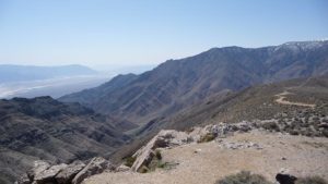 headed up on top of the rocks that make the point. Settling into a sunny protected nook, I took in the grand view, ate some cheese, drank some water, took some pictures and thanked the Universe for letting me enjoy such a sweet spot. After a while, two cars showed up with some Asian visitors. They didn’t take notice of me nor them and then I was alone again, watching the hawks, smelling the wild flowers and resting. I bet I was there a good couple of hours, which was okay, since I had all day to play on this side of Death Valley but it was time to ride some more dirt.
Going out the same way I came in but down hill, made it a bit easier. The DRZ was just simply eating these roads up. A real joy to be sure footed on rutted and sandy dirt. Next stop was 23 Skidoo. I remember the first time I had read the Skidoo sign. I thought it was some sort of winter snow mobile location!. Time to investigate what the heck a snowmobile park would be doing out here in Death Valley!
23 Skidoo is a ghost town on the west side of the Panamint range and inside the Death Valley National Park. A 20 mile dirt road in maintained condition gives access to most types of vehicles although the road is rough so four wheel vehicles typically go very slow. My DRZ loves this kind of road and I could easily run 60mph on the straights and slow down to 20 or 30 in the hills. This road was the main access road to Skidoo. Skidoo was an old gold mining town but all that 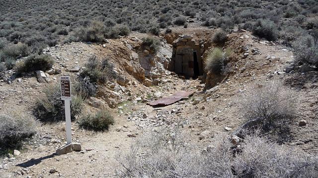 is left are a lot of holes in the ground. I mean lots. The park service has blocked them off with steel grating. Lots of sign-age warn of the dangers to people if they attempt to enter any of the mines. The 23 part of 23 Skidoo comes from the 23 miles of pipe laid to bring water from the springs at Wild Rose to this barren waste land. After poking about, I head back to the main road and the decent into the heat of Death Valley. I decide to hike up Mosaic Canyon. This is a slot canyon that periodically gets battered with flash floods from rains in the hills. The walls are polished marble and is typical of the slot canyons found in DV. The mixture of hard rock, shattered rock and soft minerals makes DV a geological wonder land. The hard rock artifacts are quite evident here in Mosaic Canyon. I hike to the upper end which opens into a wide plane and follow the dry creek bed a ways
 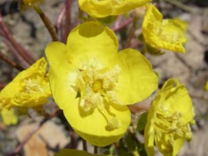 towards the mountains. Desert features abound and I find a few of the wild flowers I am in search of. Temperatures are in the mid 80F and the sun is baking hot. Hydration is so important in the desert and I frequent my sip tube
 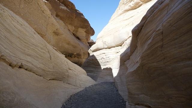 connected to my camel back.
Back on the bike, I head towards Furnace Creek stopping to take some pictures of below sea level flower fields. Not spectacular but still quite amazing for such a barren place. I arrive at the Furnace Creek camp ground to find that there are no camp sites available. Not part of my plan! It turns out that we are in peak DV season and all campsites are reserved. I head over to the DV park center and chat with one of the rangers who tells me I should go to the entry booth anyway because there are always some tent sites available. Back on the bike and over to the camp ground and sure enough there are open camp sites. Bagging one, I set up camp and plan my sun down routine.
I built a pretty standard sun down routine from Furnace Creek during my first visit to Death Valley. Sun sets are pretty amazing in DV and quite dramatic at a place called Artists Pallet, a 20 mile run towards the south of Furnace Creek. This would be my fourth sun down routine.. The setting sun illuminates the soft hills on the east side of the park. These hills have bands of chemicals making a multi colored pallet that has a golden glow as the sun sets. My MO for these trips is to get a picture of the motorcycle I’m riding with the hills illuminated in the background. I have three such pictures. (the fourth is a sad story where I forgot my camera..)
Having taken my pictures I head back to sip on my scotch, take a shower at the pool facility (They charge a $5 fee but well worth it) and find some food at the local pub. I was tempted to take a walk towards some adventure riders I had spotted on my way in to camp but decided that I would rest in the warmth of the evening and enjoy my scotch laced thoughts..
I slept like a rock. The temperature was perfect, well, way better then the ice box I slept in the night before! I boil up a cup of hot water and have some oat meal and tea. I’m planning on a trip along the west side of the valley and returning the same day so I check with the camp host to see if I can keep my site. The answer is probably but I have to pull my camp down anyway. Well, with that in mind, I decide I will end up in Beaty Nevada for the evening and ask if I can park my gear at the camp host until I get back. The host at least obliges to that so I partially pack up my back, flip the power switch on, hit the starter and nothing.
I had attempted to charge my cell phone the previous evening with a new inverter I had purchased for the trip. Didn’t work well so I had given up but apparently not soon enough as it had drained my battery. Well, you say, good thing I am in camp. Ha, doesn’t matter. I’ve got a kicker on my DRZ! Thats right, I can kick start my bike. I set the choke, kick it a couple of times and vrooom! Gotta love the look on peoples face when I pull that off! In fact, the ADV riders down a couple of camp sites saw this and one of them came up to say hello. A French Canadian came by to check out my adventure bike and chat. Turns out, he and his wife had been on the road for six months and were heading back to Toronto. They had just come back from a trip to South America, as far south as Patagonia on two big beamers. Well, an hour and a half of chatting later we bid good by and I headed out on my west side road trip.
West side road is 50 miles of dirt, sand, rock and clay. It starts just south of Furnace creek, heads west across the valley then south along the west part of the valley. My plan was to rip up some dirt to the southern most canyon road and head up into the mountains. The road starts out as a clay salt. White on either side of the road and solid packed clay along the the road bed makes for a fast ride. 60+ mph for a few miles before the road turns south and I hit the first of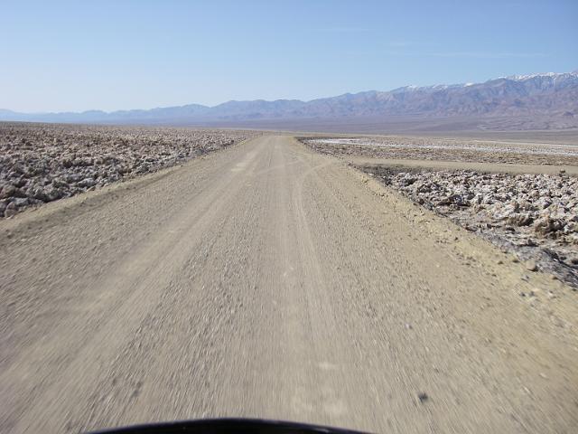 many sandy stretches. Sit back on the bike and stay on the throttle. The front end floats and the rear end swims a bit. I’ve dropped to about 40 mph and the road gets hard packed. The white has turned into the desert sandy gray with spots of green. Soon I come to a grassy oasis and Tule spring. Tule spring is a concentration of green. No visible water, lots of low shrubs and small trees. It’s dead calm as I get off my bike and my black motorcycle gear heats up fast. I get a few pictures and climb back on the bike just to get a nice 30 or 40 mph breeze flowing through my gear. The sweat evaporates off my body quickly and a refreshing coolness hits me which lasts about 5 minutes in the super dry desert air. A little further down and I come upon the
 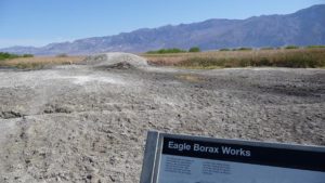 Eagle Borax site. This too, is an oasis. Borax was a big deal in Death Valley. If you are as old as I you might remember the 20 Mule Team Borax advertisements on early television. West side road is the 20 Mule Team Borax road and this is one of the borax sites that supplied the mule train. All thats left of the Eagle Borax site is a mound and dried mud. Off to the east of the mound is a huge grass land with six foot high reeds. The ground is very mushy and there is quite a lot of water present. The reeds give way to willow trees towards the south and a light breeze rustles the green leaves. For the center of the southern part of this valley of death, there is sure a lot of life. I head back out to West side road from the site and continue my trek south. More sand and loose gravel on this wide three track road. My DRZ dirt riding skills become more sure footed as I tear up this lonely road. Next stop is Bennet’s Long Camp. I remind myself that I’m tearing down road at 40 or 50 mph when 100 years earlier these pioneers were clomping a mule train
 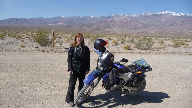 along at 2 or 3 mph. I cover a days travel in 30 minutes! Walking out of this desert would be a very big problem and I take stock in my supplies, skills, tools, knowledge of my bike, quality of my bike, and of course my SPOT. Bennet’s Long Camp is another spring in Death Valley used by the mule teams to rest their animals and replenish their water. One of several along West Side Road, these oasis made the early mining of the salts and other soft minerals possible.
As I ride towards my destination canyon road on the south side of the park, the terrain gets rockier. These rocks are 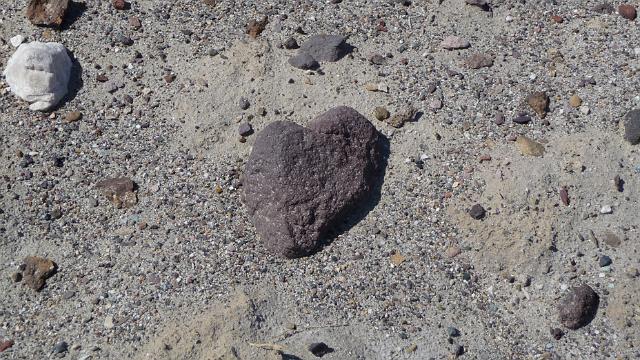 very porous and the road bed begins to turn into pumas. Volcanic activity must have blown this dark rock onto this flat valley bed. There has been some rain here as the desert flowers are more abundant yet the plants are farther apart indicating longer periods of no water and very little ground water. The road turns into a marble pumas just before I come to the canyon road I’m going to detour onto. Warm Springs Canyon road is 40 miles from Furnace Creek. It heads directly west into the Panament Mountains, Ballarat is some 20 miles over the mountains to the west. If I had tackled the road from Ballarat, this is where I would have come out. Looking west up this canyon road, it climbs gradually into some foot hills and serpentines into and over the horizon some 5 miles away. SIgns warn that there is no camping for the first 2 miles of this road. I turn up the road
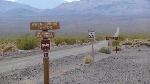 and put on some throttle. This road is not as well maintained and there are lots of rocks, pot holes, sand washes and woops. Two miles in, I see several tents in the desert where campers have put their base camps for exploration. Passing into the foothills the road adds some switch backs and more sand washes. Soon the mountains begin to climb on either side of me. The colors on the mountain walls indicate lots of minerals and I come upon several abandoned mines. I look for the warm spring for which the road is named and suspect a wet spot in a wash as being a possibility. There are several roads that seem to lead
 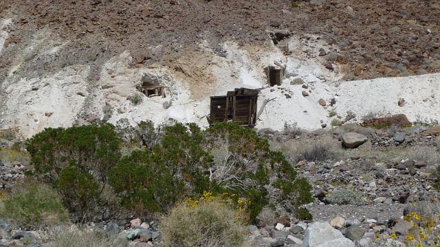 off to old mines towards the south. I keep heading west towards the Panament range and the going gets a bit more rocky. Fewer people have traveled this section of road and picking a good line through the washes becomes more and more of a challenge. Seeing Striped Butte in the distance, I decide to turn back. It’s getting into mid afternoon and I do need to find my way back to Furnace Creek to pick up my gear. I am also interested in finding this warm spring.
I pick my way through the wet wash and notice a couple of turns towards some old mines. I decide to take one of these roads which leads me to a creek that crosses the mining road.. I scout the creek to see if it is passable and everything seems pretty solid. Riding through water is a recent skill of mine and picking a line that is not to rocky or to muddy is a challenge. I make it past the creek and ride up to an old mining camp. A plaque marks the location of the Warm Springs Canyon Talc mining camp. This is a pretty big camp set into the mild slopes of the hill side. The mines are just to the east and have brilliant white talc leavings. The camp consists of a half dozen buildings that span an acre of land with a warm creek passing through a lush jungle.
Warm springs canyon was first modern populated in the 1800s. A native American built a working ranch with orchids and cattle. This ranch was wiped out by a flash flood in the late 1800s and warm springs was abandoned until a woman moved into the canyon and started mining the talc.. She set up several buildings to house the workers and eked a living from the pure white talc that was taken from the adjacent hill side. In the 1970’s tourists began driving jeeps up the canyon and stopping at her camp to enjoy the warm springs. This turned into another revenue stream for her and she built a swimming pool fed by the warm creek. Visitors could stay and camp, spend their Las Vegas winnings and enjoy the desert air in this lush little paradise.
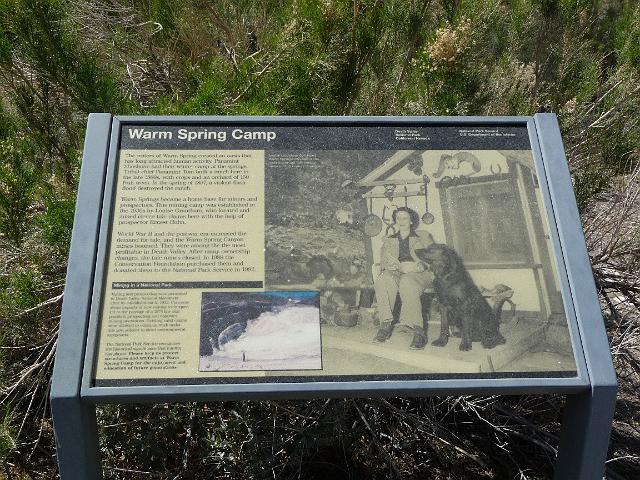 Late 1990s she died and her heirs did not continue the camp. Since the camp lies within the National Park, the park service has taken it over and closed off most of the buildings. One building remains open for jeepsters and can accommodate a full on caravan. If I had known how nice it was here I would have planned on taking my gear with me and camped for the night. Maybe next time!
A path leads up hill from the camp on both sides of the creek. The creek has dug quite a canyon in this little valley. The west side trail traverses the hillside above the creek. I climb through lush trees that break out to high reeds that disappear on either side to desert shrubs. Flowers are abundant here and green is the color of this creek bed. As I climb higher the hillside gets steeper and a few seeps can be seen coming out of the rock. The trail takes a sharp left into the creek itself, high reeds on either side. I slosh through the water up stream to a solid rock wall that rises another 200 feet higher. Someone has built a small dam to hold the water of the creek in a pool by its source. The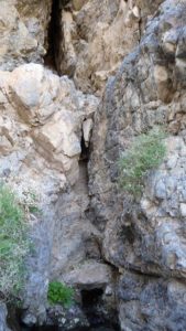 water is perfectly clear and quite warm. Looking up from the base of the rock wall where it meets the pool I can see a thousand years of seep from a vertical crack that reaches almost as high as the wall itself. Its quiet. The birds twitter and the creek gurgles while I soak in the warm water. Solitude in a desert canyon warm spring.
A quic k lunch and back on the DRZ for the ride out of the canyon. The going is fast and confident. Before a half hour has passed I’m back on West Side road tearing up the dirt heading to Furnace Creek then Beaty Nevada where I plan to refuel and restock my stores. No tourist stops on this run. 40 miles of desert dirt, plenty of gas, great bike and lots of speed. At the intersection of West side road and the main road into Furnace Creek I meet up with four other guys with DRZ’s No gear on the bikes, they are riding the desert from their base camp in a Beaty Nevada hotel. We agree to meet up and have dinner together which is a nice steak at the local casino.
Let me tell you about Beaty Nevada. If you go there, get fuel and leave. There is no grocery store so you have to settle for junk food at the local fuel stop, There is a hardware store that has a bit of fresh fruit. Otherwise you are faced with a brothel, casino, candy store (another brothel?) and several worn out hotels that look nice from the outside. I had no idea what Beaty was about and it was late, I had no choice but to find a room where I could keep my eye on my bike. I was quite happy when morning came. Theres a Mexican food place across the street so I pack up my bike and ride over. Its a trucker stop. Mexicans run the place and seems to be a pleasant family. One of the boys runs out and sets my table, gives me a menu. Then I wait. And wait. The waitress clearly despises me. She sucks up to the truckers and ignores me until I flag her down. She then looks down her nose at me and takes my order. This is so obvious that I have to laugh at her behavior. The last time I was treated this way was in a little town in southern New Zealand!
Out of Beaty, Fueled up, a couple of bananas and an apple in my bags and off to Rhyonite.
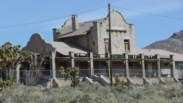 Rhyonite is a ghost town between Beaty and the entrance to the Death Valley. It was built up in the 1920s and abandoned in the late 1930s’ The town managed to have a train spurred into its valley so that the Rhyonite (a sort of pumis?) could be hauled out. The railroad station is quite a piece of southwestern architecture and is fenced off by the park service to keep looters from tearing it apart. The rest of the town is nothing but old stone building walls. It is interesting to guess what walls belonged to what building. The bank was obvious as was the livery and train station. Lots of tourists here so I mount up and fire off down the dirt access road to Titus Canyon road.
Titus Canyon is one of the destinations for my trip. Last trip I had my sv650 and didn’t dare take on Titus. I had hiked up a bit of it from the valley side but did not do the one way road down from the Nevada side. I had heard stories that there were lots of washes and deep sand but passable by most four wheel vehicles. This trip I had Dr.Z! From the high desert outside of Beaty, the Titus Canyon road is straight and fast. Lots of one way signs at the beginning making it clear that once you are in you are going all the way down to Death Valley. The straight desert road with woops gives way to rolling hill sides. As I descend I can see the road twists its way into a canyon then climbs through a series of switch backs out of this canyon and over a crack in the mountains ahead. Off in the distance I see one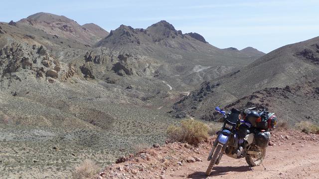 vehicle. A monster of a truck with wheels taller then my bike when I stand up on the pegs! How the heck is that thing getting up and through this road.
The road itself is well groomed. There are a couple of sandy spots which might pose problems to a street bike, but the DRZ with knobbies just cruises through. I stop near the top of the switch backs I had seen earlier and enjoy the look back at the desert road I have just run. The many colors of the soil and rock make this particular desert so remarkable and I soak in the wonder of the geology.
Topping the mountain crack, I look down a long canyon with multiple switch backs. Ive gained on the big white truck and can see it below me several switch backs ahead. The road is steep and the switchbacks are full 180 degrees with some run off. The road bed is in good shape and the surface very predictable so the going is pretty easy. I pick up distance on the big white truck.
Near the bottom, the big white truck is on the last switchback and pulled into the runoff. Now, I’ve never quite seen a truck like this. Huge would be an understatement. The fact that it is this far into Titus canyon makes it quite remarkable. Clearly this is a fully custom go anywhere truck on some kind of military hardware frame. The tires alone are five feet in diameter. The box, which is customized with a Big picture window, sits above the ground at least four feet and the frame clearance must be at least 2.5 feet. This is the ultimate go anywhere all wheel drive, tight turning radius, monster truck wheels RV. I putt by in the DRZ and give the couple in the drivers cabin a wave.
The road is now in the Titus canyon wash. Recently graded, the wash road is all loose gravel and the going is squirrelly but ridable on the DRZ. I catch up to a couple of bicyclists who have been cruising down hill in front of me for a while. Their tires dig in a bit more then mine and are more selective about the road surface they ride on. I lay back and study their pattern before pulling by and speed off to the next stop along Titus, Lead Ville.
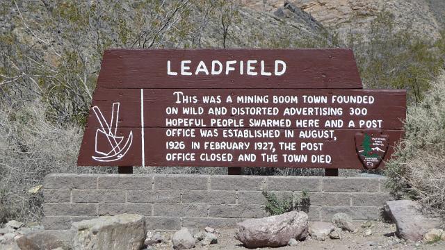 Lead Ville was one off those tiny boom towns that sprung up all around Death valley in search of gold. It was over promoted and managed to gather 300 plus residence, mostly men looking for their fortune. The mine produced small amounts of lead and not much else. Lead Ville was only open a few years before the town collapsed.
Water for Lead Ville came from an ancient spring further down the canyon. Down the wash a ways, I come across lots of tall grasses. A sign calls out the spring and points out petroglyph’s by Native Americans. No one knows what they mean but I would guess they are related to the spring some how. I stop the bike and look about for the spring. There is a game track that dives into the tall grasses and leaves, so I push my way into the grasses and the ground gets really mushy until I hit water. Another little oasis in an otherwise dry desert. Sitting on a rock below the canyon wall, I listen quietly, the grasses tussled from the slight breeze, the intense sun raises the moisture through the spring time vegetation and I enjoy a heavenly moment in an ancient setting.
The bicyclists have passed me and moved further into the canyon. The walls get steeper and smoother from millenniums of flash floods. Some of the wash patterns and walls become familiar. The year before, I came this way on a hike from the bottom of the canyon. I pass a hiker, a late middle aged guy with carved features. He is hot, tired but smiling with that internal pleasure of being alone, deep in a canyon. I know that feeling. Further down the wash, I come to a place where the canyon narrows to vehicle width. Just before this slot, there is a beautifully shaped wash and dry water fall to to the right of the road. I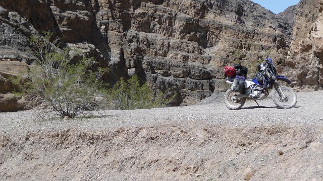 park the bike high on a gravel bank over looking the drop into the slot canyon and find a shady spot to sit, drink, eat and feel the ancient gravel. After some quiet time, I’m ready to finish the bottom of the canyon and pop out to the northern side of Death Valley, having dropped about 5,000 feet from Nevada side. The bottom is all slot canyon. The
 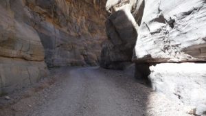 DRZ’s open throat exhaust echoes down the canyon with a familiar and hardy rumble. This is one of the best rides in Death Valley. I would recommend it to anyone with a dirt friendly bike.
Popping out of the canyon wall as it meets the effluvia field of Titus, the Valley opens up into it vast dryness. The dirt parking lot where hikers park is filling up and I feel some sorrow for some of these people who will never get far enough into Titus to really appreciate its wonders. Leaving a tail of dust, I fly down the road to the main paved route that takes me to the northern corner of the park and Scotties Castle.
Scotties Castle is a remarkable complex built around and in a huge oasis. Giant weeping willows grace the roadway as I approach the castle. The castle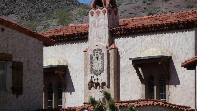 complex has a gas station but the tanks have leaked and it has been indefinitely closed down. Nearest gas is 40 miles away at Stove Pipe Wells. That doesn’t deter thousands of tourists in there giant rv’s from making the trip along the well maintained paved road. Riding into the giant parking lot, I take a ‘show off’ loop to find a spot for my serious off road go anywhere setup. I get lots of strange looks from the air conditioning crowd and a few smiles from the more hardy looking tourists. I find an appropriately obvious spot near the walk way to the complexes center, dismount, peel off my riding gear and put my Aussie safari hat on my head to protect me from the sun. The obligatory tourist shop has some bottled ice tea, water and a candy bar which I collect and pay for. Finding my way outside to a picnic table in the sun, I soak up the heat, drink the cool tea and wolf down the candy bar before it melts.
The story of Scotties Castle starts with a non existent gold mine, a cowboy, a Chicago insurance sales man and his very religious wife. You can fill in the story from there or google it for all the details. The castle is a real castle, motes, bridges enclosed court yards and the obligatory tunnels and turrets. It has a marvelous clock tower with a sundial for a clock face. A great court yard with huge wooden gates made of the local iron wood. There are tours every couple of hours which are populated by the tour bus and RV crowd. I sit and watch this turn over of tourists for a while, soaking some sun. I’m in no hurry this afternoon as I will be heading over the mountains to Saline valley the next day and I need to conserver my gas. I’ve burned about 40 miles worth since I’ve left Beaty.
As the afternoon wears on I head out to Mesquite camp ground. The 5 mile ride from Scotties is quick. There is a short dirt road run into the camp ground which passes through a small Weeping willow glen where the spring for the camp ground is located. This camp site has good water. The actual camp ground is very exposed desert with lots of mesquite bush. I locate an empty site where I can plant my tent in the wind shadow of some giant bushes and set up camp. This camp ground is mostly RV’s and no other motorcycles. The neighbors walk by and give me odd looks.
 Mesquite camp ground is by a large wash. When the mountains to the north and west get rain, this wash must turn into a raging river. The wash sits a good 10 feet lower then the desert and has carved a distinct path towards the south central part of the valley. Its a great place to investigate the rock and gravel. I pick a few stones for my collection and continue to investigate the wash. A tributary wash comes in on the opposite bank and makes for good climbing. I pass a couple of hikers as they make their way back to camp. The wind has died down a bit and is now just a whisper as the shadows grow longer hinting at a sunset.
Back at camp, I eat a few rations and warm up some tea. The air is cooling down now that camp is in the shadow of the western range. To the east is a a gold band of mountains from horizon to horizon. The shades of rich warm yellow, golds, oranges, reds and browns slowly change and fade to gray making for a priceless afternoon sunset.
In the waning light I review my maps and my road options for the next day. I had planned the day to be my most aggressive portion of the trip. The roads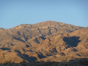 I’ve taken have prepared me for the desert, mountains and canyons that would be part of this final off road section of my trip. I mentally calculate the fuel I’m carrying and decide I’ve got a comfortable 170 miles left in the tank and could push it to 200 with the spare MSR tanks in my tank panniers. I have a full camel back and two 1 liter bottles of water. Good for a solid day or two if I stretch it. Nuts, fruit and some beef jerky will cover my day run through the desert. I plan on staying at Panamint springs the next evening so there is no need to pack more. I carefully review my emergency items, including a water purifier for the two springs that I may find en-route. Turning on my head lamp, I secure my camp and take a twilight stroll around the grounds, ending at the bathrooms to leave a contribution before retiring into my tent.
I always wake up at the first sign of light. This morning was no different. Its cold out and I crawl into my fleece top. I know it will be getting very hot later and prepare with a tank top against my skin. I get the courage to just wear my convertible pants and crawl out of the tent to an explosion of morning gold on the western mountains where I will be heading after a quick breakfast of oatmeal, raisins and evaporated milk. The sun has not quite made it over the eastern range yet and I’m all packed. I want a real early start towards my first destination Ubehebe crater.
The road to Ubehebe is paved. There’s not another vehicle in site and the DRZ is putting along through the golden morning desert. The road heads into the northwestern corner of Death Valley and rises quickly into the mountains. The desert turns a scorched black with small twigs of vegetation poking through the 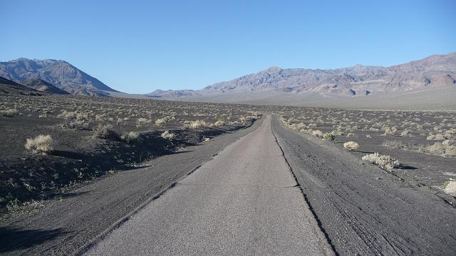 pumice. I’ve entered the blast zone of the Ubehebe volcanoes. The road turns into a single lane one way and climbs to the edge of the largest crater. Nearly a thousand feet deep from the crater’s rim, it is truly an ancient volcano. The placard tell of a devastating explosion some 2000 years ago, laying the land to waste for 20 miles or more and leaving black pumice for a good
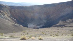 seven mile radius. Getting of the DRZ, I take a few pictures to record my travels and remount to head down the unpaved Racetrack road. Racetrack is my second destination this day. It is 22 miles of wash board road through a high mountain desert valley. The DRZ easily hits 40+ on this road and smooths out the wash board. There are plenty of rocks, bumps and whoops so standing on the pegs is a requirement. No other vehicles in site. The early start has put me well ahead of the tourists in their air conditioned SUVs and I enjoy the clear air in my face. The road has wide
 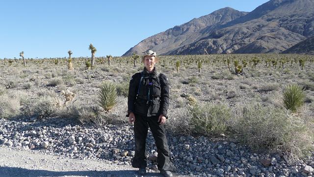 turns and slowly climbs into a forest of Joshua trees and low cactus. Mountain tops rise to the east and west while the road twists and turns through easy sand washes and bony exposed bed rock. I wouldn’t take a street bike on this The road and the DRZ is more then perfect for this kind of riding, even fully loaded.
In the distance, along a particularly straight stretch, I see an odd feature standing bolt up right and glinting in the mid morning sun. My gps indicates a cross road coming up. Soon the glinting turns into a a clump of sparkling diamonds and that evolve into a very strange site. Teapots of all shapes and kind hang from a sign post declaring a road to Hunters pass and another road to the Race track. This is Teapot junction. An obligatory stop and take pictures. It seems that for years if not decades, passers by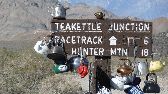 have left an old teapot with a message, hanging from the sign. A hot desert breeze tinkles some of the pots together. The sign post is set into a pile of rocks and stands a good seven feet high. Twenty or thirty teapots hang glinting in the sun shine. I set up my camera and do a series of poses with my hat, without my hat, with my sun glasses, without, sitting and standing. After firmly establishing that I have come this way, noting the distance to Hunters Pass (30 miles) and to Race track (7 miles) I mount up and head down the last few miles to Racetrack Playa.
The road winds through a series of slow switch backs and slight grade through a few foot hills to a gigantic dry lake bed. When it does rain (a couple of times every five years) the lake bed captures runoff from the surrounding mountains There is no exit for the water, so the muddy, volcanic pumice laden water just sits in this valley and dries up leaving a perfectly flat surface. More often are smaller rain storms that simply make the surface of the dry lake bed wet. The sun comes out and bakes it dry again. Over and over this happens and what I see is a perfectly flat surface. I ride to the southwest end of the lake where there is a small parking lot and a sign describing the scene. 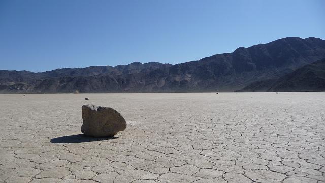 Caution signs ask that I do not ride on the lake bed or walk on the lake bed when it is wet. It is bone dry now, and hard as concrete. Off in the distance I spot a few dots on the lake bed. Dawning my hat, camel back and camera, I head out across the the lake bed towards the dots. The lake bed is composed of dried fine grain mud. The texture of the surface is an endless set of hexagons like you see when looking close at bubbles bumping together. They vary in size but are all less then two inches across and larger then 1 inch across. Here and there are little pumice chunks that must have been blown in by the wind. Some are slightly embedded into the surface and others just sit on top ready to be blown some more. Looking closely at these chunks I notice some have different bubble patterns. Most have the
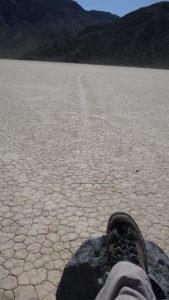 open crater surface that I’ve seen on volcanically exploded rock. Every once and a while there is one that has a closed bubble surface. Looking more closely, these odd pebble size stones are more embedded into the surface. Pushing one loose, I notice it is quite a bit heavier then the normal pumice style pebble and I realize that this heavy pebble didn’t just blow in from mountains. This pebble got tossed on the lake by the Universe itself! I was walking on a shoreline of the Universe where a wave every now and then would toss a meteorite onto the lake! It’s not that astounding really. Daily, the Earth gets pounded by rocks from outer space. We just never see any of the debris because these small meteorite pebbles get mixed into the vegetation and rocky eroded surface material or water that makes up the Earths surface. But here, on an ancient dry lake bed, where there are few other stones to be seen, well, those meteorites show up! My new found realization of walking along the shore of the Universe makes me feel both tiny, insignificant and honored at the same time. Making my way further onto the lake bed I start seeing tracks in the dried mud surface. Following one set of tracks that looks like a vehicle, I come to the end of the track where there are two rocks. But there are no foot prints around the rocks. Just the tracks leading across the lake bed. Surely these rocks didn’t move them selves? One rock seemed to be just in front of the other as if racing. I’ve come to the name sake of the lake bed. Race Track. Here, many dozens of miles away from civilization, in the dry desert bowl of a valley, is a place where rocks race across the lake bed. I can imagine the lake bed being pelted with rain and the mud getting slick. Then a big wind comes and blows any object sitting on the surface, moving it down wind across the lake bed. On my walk about, I found dozens of rocks. Some a foot or more tall and wide, weighing several hundred pounds and long tracks behind them as if traveling with purpose across the lake bed. Race track is a truly amazing place. I take my photos and retrace my steps back towards my patiently waiting DRZ.
As I return, a red jeep rolls into the parking lot. I sit along the side of the lake bed changing into my riding gear and chat a bit to this Italian fellow who spoke some English. He asked if the road went all the way through. I cautioned him that my maps showed it did but that it was un-maintained and required high clearance, probably more then the jeep would be able to handle. He nods, bids a goodbye and takes his walk about on the dry lake bed. He was the first person I met so far off the beaten path .
Sitting there alone, I do some mental math on my fuel supply. So far I’ve burned through 40 miles from Beaty NV to Mesquite Camp, 10 to Ubehebe, 30 to Race track makes 80 miles off my 220 capability (with my two little reserve tanks). Getting stuck out here without gas is not an option. I already know that Scotties does not have gas and my nearest supply is Stove Pipe Wells, some 60 miles back the way I came, or 40 miles down a high clearance canyon road or 50 miles over Hunter Pass back at Tea Pot Junction. The safest option is to head back. I would burn another 60 off the tank taking it to 140 leaving plenty to spare. I could go forward on Lippincott, the canyon road which would take me to 120 miles and if I needed turn around I would still have enough to back track or I could take Hunters pass where I might not be able to turn around and have enough to get back. Its early in the day, not much past 11 am. Still plenty of day light and I’m out here for an adventure. I would like to preserve my option to turn around as much as possible. Lippincott is just a mile down the road and the canyon portion is a mere 7 miles long before I’m in Saline Valley and on my way out a road that appears to be maintained on one of my maps. I need to at least see this Lippincott road and canyon. I could still turn around and head back to Stove Pipe Wells. The Hunter Pass route would be a 40 mile commitment before I got to the 4 wheel drive part and if I had to turn around there I might not have enough gas to back track. The obvious choice was to go the mile towards Lippincott and see how the road turns out.
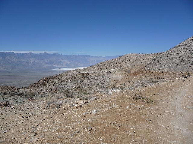 Less then a mile, I come to parking area-turn-around with an un-maintained road heading west through a saddle in the mountains. Thats a good sign. The bad sign is big, a really big sign standing ten feet tall and 10 feet wide. It states that Lipponcott is an unmaintained road with washouts and may be impassable at times except in high clearance vehicles. Only experienced four wheel drivers should attempt this road. There are no services. I look at the sign, I look at the road. Point the bike at the road and head down Lipponcott through the saddle.
Lippincott is a narrow two track. Very bony, with lots of loose stones. The grade slowly increases and begins to drop across steps of rocks, some a bit higher then I would like. The side of the road slopes gradually up on one side and down on the other. The road runs off to a smoother traverse and after a few minutes I stop at a lookout where I can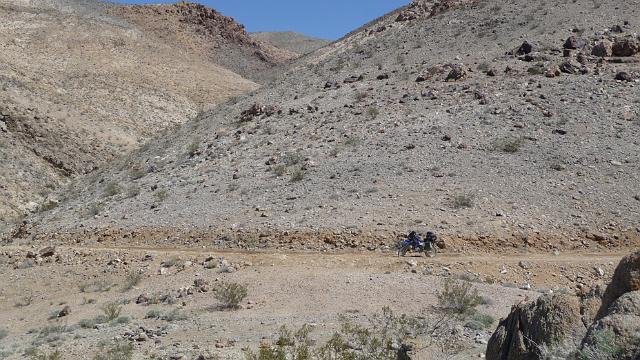 see Saline Valley, where I’m hoping I will find a maintained road. So far so good, although I feel a bit less confident about riding back up and out the way I came. My options are closing.
I take a picture of my little DRZ with a mountain side behind it. The road leads west then turns north between a rock outcropping and the mountain. It is hot. I sip a bit of my water, mount onto the bike with hopes that I’ll be able to ride fast enough for the air to evaporate my sweat and cool me off. I take the turn between the outcropping and see the canyon on my right open up. The road turns left and drops off into what appears to be nothing! The road is washed out on the inside track with lots of loose rocks, the outside track (the one next to the canyon) has some solid ground but that disappears in another 50 feet and the entire road is loose rock. I decide that I’d better stop and take a look at this as 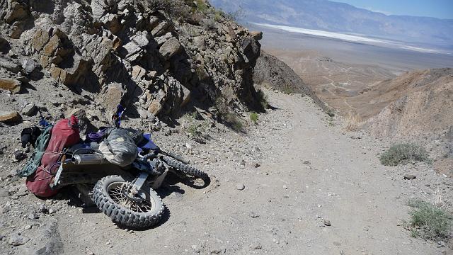 the road traverses and continues to steepen. I grab for some brake and put my left foot down which finds nothing. The washed out inner track provides no place for my foot and I can feel the bike going down. I let out the break in hopes I can right the bike in the wash but no joy. The bike drops between my legs, fortunately on the inside track. I step out of the way. Adrenalin is ripping through my over heated body. I first try to right the bike with all my gear on board. Not going to happen. Time to step back, sip some water, take some gear off, but not before I get my camera and record my demise! I want a record of this so that when someone finds my vulture picked bones they can see how crazy I was! I pull of all the gear from the rear of the bike. Empty the saddle bags and get the bike up right. Great, I’m in the washed out gully, pointing down hill. I’m not going to try to swing the bike around so I’m committed to going down hill. Where I am does not allow me to get the kickstand down. There is a smooth packed sand spot out at the edge of the road so I use break and clutch breaking to walk the bike over to the edge of the canyon and get the kickstand down. Now what. Surveying the scene, I can see that there are five switch backs to get down the canyon. Way off in the distance I can see Lipponcott continue towards Saline valley. I don’t see that maintained road though, just another mountain range. I scout the stretch of road I’m on, looking over the rocks to find the friendly ones and the bad ones that will shift if I cross them. I decide on a route that will take me along the edge and then back towards the inside where I can get a good left foot against the up hill wall of gravel and rock. Using a trick that I learned years ago, I keep the engine off and use the clutch as a break. The road is steep so
 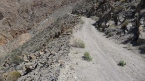 there is no problem keeping the bike rolling and by using the front hand break and the hand clutch I have both feet on the ready to keep the bike up if I need to stop. This first stretch begins to level off and smooth out so I let the bike glide to the switch back, put the stand down and take a look at the next stretch. Its just as bad. This stretch ends at the box canyon wall and switches to the opposite side. From where I stand, the other side looks a lot better (I tell my self,knowing thats a crock of bull). More clutch breaking and I get around to the other side of the canyon. That nice smooth road I saw is nothing but wash with everything looking loose. I scout this section and move some of the foot ball size rocks out of the way so that I have a reasonable path through the wash. There are no turns until the switch back and the run out looks smooth so I mount the bike and find my way through the loose wash and glide to the turn. There is one more switch by the box in the canyon then along the wash at the bottom of the canyon. There are
 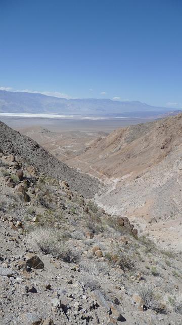 only a few loose dry arroyo. I fire up the bike, which has been off for the past hour, and thump my way through this last section. The road gets less steep and the arroya falls beneath the road with the road traversing along the north side. It is loose rock but not to steep and easy to navigate the lines that are good for a bike. I come to an abandoned mine area and which has a spectacular view of Saline valley and where the road turns to the southwest out of the canyon, across some small hills, disappears then reappears again as an arrow straight line across the southern edge of Saline valley. I through my jacket over the bike to get some shade from the sun, pull out an orange I’ve stashed away and settle for a little rest and re-energizing in what little shade my bike affords.
The abandoned mine has a lot of tailings. There is an old pipe that winds its way up hill towards some un seen spring. It is hot. I feel really good. I’ve made it down some of the worst road I’ve ever been on and I’ve accomplished my goal of having an adventure. Still, there is a lot of ground to cover and I have no idea where the maintained road begins.
Back on the bike, I’m able to get to 20 mph. The dry air evaporates my sweat and I cool down. The road is bony and there are numerous arroya as I make my way out of the hills and into the valley. Once on the valley floor the road is straight and deceivingly smooth. In reality is torn up with loose boulders strewn everywhere making it a technical ride. Wide dried arroya are interspersed along the road making for some excitement. the road gets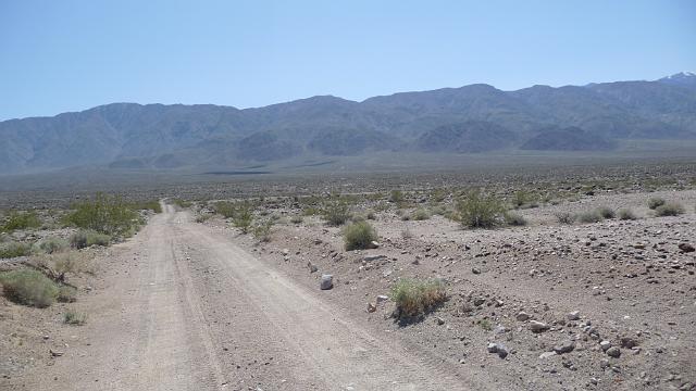 rockier as I ride further west until it seems to be nothing but grey stones the size of baseballs across both tracks. I still don’t see the road I’m looking for and begin to worry that I might have to cross another mountain range before I find it. Looking at both my maps, one indicating four wheel high clearance only and the other indicating maintained I get a bit anxious. Moving again, at a good clip, I finally see the road end at the T intersection both maps ( and my gps)
 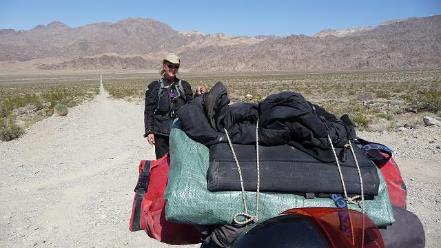 indicate. At the intersection I take a break, snap a few pictures and watch a Toyota Camry lope along the Saline Valley road. I guess this is the maintained road!. One last picture of a smiling Paula with thumbs up and Lipponcott disappearing across the valley in the distance.
Saline Valley road is a well maintained back road that connects the hot springs in Saline Valley with the main paved road and Panamint Springs, an oasis on Rt 190 near the junction of Panamint Valley Road and the road over Emigrants pass into Death Valley. Panamint Springs has a camp ground, general store, restaurant and the all important gas station. I’ve got plenty of gas left and lots of day light (it is just after 1:00pm) so I fire up the DRZ and head on south through a nice (hot) sunny day. The road quickly turns into a series of sweepers that dip and rise across washes and finally begins to climb towards Hunters Pass. The climb is steep and serpentine as it traverses the valley/canyon that rises towards the north pass. Rounding a corner, I feel a cool breeze and find a green oasis. Splashing through two streams, I’m reminded of the life that can be found in desert canyons. (I highly recommend the ‘The Secret Knowledge of Water’ by Craig Childs for information on desert water). Rising to the top of the canyon where the road turns and levels out, I stop Dr. Z and take a breather in the 1000 ft altitude air. Looking north is the land drops off with dots of vegetation mixed into rock and finally flattening out into long red lines that meander through the white salts of Saline valley. Taking tart bite out of my last apple, I can’t help but smile, breathe deep and thank the Universe for such an exciting experience.
The silence of the breeze in high desert is broken by the familiar thump of several single cylinder bikes. Rounding the corner come four DR 650’s and riders geared up for a day ride. Stopping in the road next to my fully loaded, self support DRZ they look ‘recreational’ rather then ‘adventure’ The first rider hops off,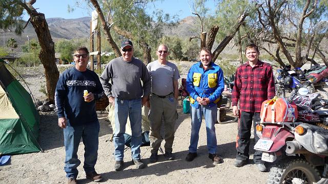 takes his helmet off and looks at me with a strange sideways stare asking ” are you the crazy lady that came down Lipponcott alone fully loaded?” To which I answered “why yes, how did you know?”.
So began an interesting conversation and story swapping chapter where we camped together, ate together over the rest of the afternoon evening and following morning.
Homeward bound I hit 30 to 40 mph head winds which beat the cr@p out of me. I was happy to stop at Kernville again for a much needed rest. The following morning was a fabulously sunny day. The run across the valley was warm and calm. The weather was so good I decided to extend my trip to take me up the coast from LA to San Francisco along Big Sur. The off shore breeze was warm and the views were spectacular along rte 1. Stopping at Jade beach, I took a few minutes to hike down to the stone shore to try my luck at finding a green jade rock. Not really knowing what I was looking for I did manage to find several stones that clearly seemed out of place and had the dark green tinge characteristic of Big Sur jade. Hiking back up to Dr.Z I mount up and travel with the traffic north along the twisties and into the sunset arriving back at my San Francisco home late in the spring evening.
So ends my amazing 2009 Death Valley adventure. I hope you enjoyed reading this story as much as I enjoyed the adventure. I thank all those that helped me become the adventure rider I am and all those who were kind to me during my trip. Take care, ride fast, take chances, stay alive. Paula
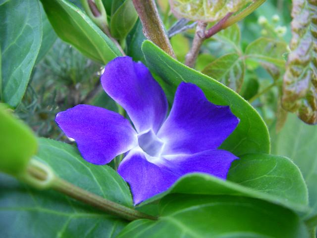
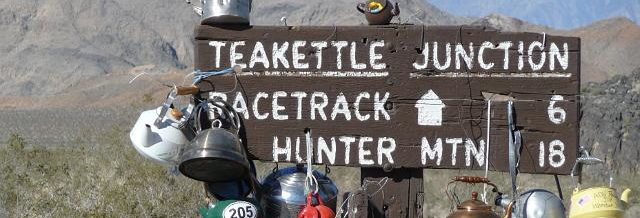
Recent Comments